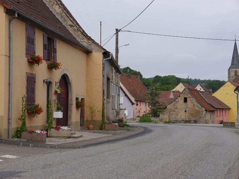
I found myself at the start of last week stranded in the small city of Trier in West Germany for a couple of days, near Luxembourg, until the rain finally lifted. I’d pitched my tent on a scenic hill overlooking the city, just behind a hedge, next to a church. It was so well hidden that I could leave my things there for the day and wander around the city.

Trier Cathedral from the hill I was camping on. Trier is apparently the oldest city in Germany.
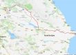
The choice of cycle paths in this region is simply amazing. If you ask at the tourist office on any of the small towns on the river Saar, like Konz, Saarburg or Merzig, they will be more than happy to give you a free map of all the cycle paths in the region (a good one is “Grenzenlos Radeln“, or “Cycling Without Borders ‘Along the Moselle, the Saar and the Sûre Rivers’ “). What’s more, is that the quality of nearly all of them puts even some of the cycle paths in the Netherlands to shame. Click here to see a map of (roughly) where I’ve been for the past week.

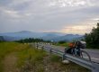
Literally spoilt for choice in terms of cycle routes. You can cycle hundreds of kilometres through stunning scenery without ever being on a road.
There’s a reason the Germans have built a lot of good cycle paths here: there’s some pretty beautiful scenery to be found. Most of the paths I took followed the river Saar, as it slowly meandered through the steep banked hills covered in grapevines, passing some small villages on the way. Nearly all flat too, as most of the paths are on banks of the rivers and streams, cutting through the hills. There simply is no better way to see this part of the country. Well actually…a helicopter might be cool.
That night, after spending probably too much time reading, writing and eating cakes, I camped up in a small clearing next to the river and near a dam. It was a pretty lousy spot: very noisy with the road and a railway line nearby. But that was nothing compared to the thunderstorm that gradually overshadowed the area. I had very little warning that it was coming too; because the hills are so steep, you can only see the sky directly above. The light from the lightning was sometimes so bright that with my eyes closed, I saw my eyelids light up bright red from the inside of my tent, much the same way if you are directly facing the sun with your eyes closed. When it was all over, I hardly even noticed the cars and trains passing by, and fell asleep.
 I woke up around 6am to a chilly, gloomy fog clinging to the surrounding hills. But although it wouldn’t be sunny again for the next few days, it soon warmed up. I continued on my super slow-paced journey down the valley, now the river becoming wider as it approaches the border to France. Towns began to merge on the banks of the river as the hills gradually melted into flat land, and the trees morphed into factories and warehouses. Finding places to camp was becoming difficult again, especially near Saarbrüken, the last major city before the river leaves Germany, or rather, becomes the border between Germany and France, which I was to cycle down later that day after another thunderstorm had passed. I camped up behind a retail shop, that looked like it had been closed down – there was a nice patch of grass round the back through a hole in the fence.
I woke up and had breakfast by the Saar for the last time. Sadly, when the river enters France it becomes a little less interesting, at least where I was. The cycle path leaves the river and joins a canal running along side: flat and straight, but a bit boring. So repetitive, in fact, that if you cycle on it for long enough and then stop, the ground appears to be slowly moving away from you, like an optical illusion. I left and went off across the farmlands on country roads heading East towards the French-German border.
The roads I was taking passed through many small villages like this one in the French countryside.
I spent a lot of time this day reading and listening to music until the batteries died. So I never went very far, maybe only 50km. I drank half a bottle of wine and watched a movie in my tent, also watching the slugs climbing all over the flysheet. Also there’s not enough benches in the world. The world needs more benches, strategically placed.
The next day was great though. As I reached the border between France and Germany the hills came back, offering some stunning scenery and nature with it.

A village lies nestled in the hills on the French German border.
I even managed to find some peculiar parts where people were speaking German in France and vice versa. After losing count of how many times I crossed the border, I camped up for the night just before some more rain kicked in. The next day I ended up cycling over more hills and eventually wound up at Wissembourg…

Wissembourg in France, near the German border. A lively and very picturesque place.
Unfortunately for me, the French decided to have a revolution on this day many years ago, so everything was closed. They also failed to notify me of this, so I was pretty hungry all morning. Luckily, the Germans never had a revolution on the same day, so I just went back to Germany for breakfast. In fact, I just stayed in Germany. I found some more awesome cycle paths again. This time, the one with the picture of the carrot seemed to be good. Kinda…farmy.
 It wasn’t long before I had reached the valley of the river Rhine, gliding down from 450m at the border and into the flood plains. I wound up in a large forest, spanning a few kilometres, found a chair and sat and read for most of the evening. The weather, by the way, has become noticeably warmer the further south and inland I’ve travelled, climbing to about 30°C more recently.
 And now I’m in Karlsruhe, a bustling city set between the hills and the Rhine, recharging my batteries.

Another great report…loving the chair x
Another great read. Thanks.
The map is cool. They have some wunderbar names for their places:
Kaiserslautern – which may be where Wilhelm met his maker.
Rockenhausen – where they have a real big disco
Bouzonville – where they go for a drink after the disco
Worms – they get from eating too many frankfurters
Klingenmunster – something out of Star Trek
Baumholder – where they make lederhosen
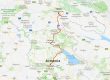
Lets have some more maps …